-
Chapter 2: PHYSICAL GEOGRAPHY OF INDIA
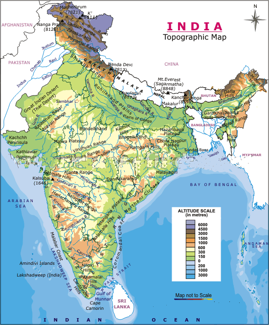
Introduction
Indias latitudinal and
longitudinal extent is 30°.
North-South distance is 3214 km and east west distance is
2933 km. North lies
in subtropical and warm temperate region and south lies in
tropics.
It is the 7th
largest country with 3.28 million sq km and 2.4% of worlds
land surface and 17%
of the population. It has 6100 km of coast in mainland and
7517 km along with
the islands.
Gujarat has the longest coastline and Bangladesh shares the largest border with India. In all there are 7 countries not counting Tibet that India shares a border with.
Indira point in Nicobar Islands is the southernmost tip of India.
Physiography of India
Physiography deals with the study of the surface features and landforms of the Earth. On the basis of tectonic history, stratigraphy and physiography, India may be divided into the following four physiographic divisions:
The elevated Peninsular region
The mighty Himalayas and their associated young folded mountains
The Indo-Gangetic-Brahmaputra Plains
The Coastal Plains and Islands.
Major Geological Formations of the Peninsular India (about 3600 million years ago)
The North Central Highlands: They include First The Aravallis (It is one of the oldest folded mountains of the world). The Great Boundary Fault (GBF) separates the Aravallis from the Vindhyan Mountains. Secondly, Malwa Plateau has two drainage systems, one towards the Arabian Sea (Narmada, and Mahi], and another towards the Bay of Bengal (Chambal, Sind, Betwa and Ken) joining the Yamuna river. Finally the Vindhyan ranges (Maikal Range forms a connecting link between the Vindhyans and the Satpura mountains).
The South Central Highlands: It has Bundelkhand and Vindhyachal-Baghelkhand or Vindhyachal Plateau.
Chotanagpur plateau: Plateau sprawls over parts of West Bengal, Jharkhand, Chhattisgarh, Odisha and northeastern part of Andhra Pradesh.
Meghalaya Plateau and Mikir Hills: Consisting of the Garo, Khasi,Jaintia hills and the outlying Milar and Rengma hills, it is a plateau which has been detached from the Indian Peninsula by the Malda Gap.
The North Deccan (Maharashtra Plateau):Plateau of Maharashtra includes the enti re state of Maharashtra, except the Konkan coast and the Sahyadris.
The South Deccan
The Western Ghats:The Western Ghats or Sahyadris run parallel to the western coast for about 1600 km in the north south direction from the mouth of the Tapi river to Kanyakumari (Cape Camorin). The western slope of Sahyadri is steep while the eastern slope is gentle. These are block mountains formed due to the downwarping of a part of land into the Arabian Sea
The Eastern Ghats
Physical Geography
The physical geography of India has four parts:
1. Northern mountains.
2. Northern plains.
3. Peninsular plateau
4. Coastal plains.
Northern mountain:
The northern mountain complex contains Himalayas, Trans Himalayas and Purvachal. Himalayas are in north, Hindukush and Sulaiman are in north west and Purvachal in east.
The Himalayas are true
mountains. They are formed
from the continent - continent plate collision. They
have sediments of marine
origin. It is not a single range but a series of ranges.
The Himalayas have three ranges namely great Himalayas [Himadri] , middle or lesser Himalayas [Himachal] and outer Himalayas [Shiwaliks].

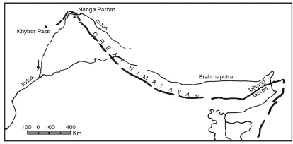
Fig 1: Himalayan range
Types of Himalayas
Greater Himalayas:1. Highest and most continuous mountain range in the world. The Greater Himalayas are almost a contiguous range. The range has very few gaps mainly provided by the antecedent rivers. The Greater Himalayas receive less rainfall as compared to the Lesser Himalayas and the Shiwaliks. Physical weathering is pronounced. Erosion is, however, less effective over the Greater Himalayas as compared to the Lesser Himalayas. Being lofty, they have very little forest area. The Greater Himalayas are about 25 km wide with an average height above 6100 metres
2. Crystalline rocks.
Middle Himalayas:
1. Less in height and discontinuous. The width of the Lesser Himalayas is about 80 km with an average height of 1300-4600 m. It consists, generally, of un-fossiliferous sediments or metamorphosed crystalline.
Outer Himalayas:
1. Upliftment of the foothills of the Himalayas. The Shiwaliks extend from Jammu Division of Jammu and Kashmir State to Assam. In width, Shiwaliks vary from 8 km in the east to 45 km in the west with an average elevation of about 900 - 1500 m above sea level. It is not a continuous range. It is broader in the west and narrows down In the east. Between the Shiwaliks and the Lesser Himalayas are longitudinal valleys called Doons / Duns.
2. They are created due to the alluvial deposit of the Himalayan rivers.
Structure of Himalayas:
1. The middle bend is convex shape.
2. Second sharp bend is towards southern end.
3. Western bend towards Nanga Parbat and eastern towards Namcha Barwa.
4. Northern side rests against Tibetan plateau and southern side is covered with snow. Gentle slope on northern side and steep slope on southern side.
5. The mountains don’t act as a water divide but allow rivers to cut across. The rate of erosion by rivers is greater than the rate of upliftment of Himalayas.
|
Western
Himalayas
|
Eastern
Himalayas |
|
Lower and gradual slope. |
Higher and steep sudden slope. |
|
Located on higher latitudes and so colder |
Located on lower latitudes and so warmer |
|
Don’t act as barrier to south west monsoon |
Act as barrier to south west monsoon |
|
Shiwaliks are farther |
Shiwaliks are closer |
TABLE 1: EASTERN AND WESTERN HIMALAYAS
Region - wise division of Himalayas
The Himalayas are divided into five regions:
1. Kashmir Himalayas
a. Karakoram, Ladakh, Zanskar, Pir Panjal and Dhauladhar are the ranges from north to south in that order. It has the largest number of glaciers in India.
b. Karewa formation – clay, sands from old fertile lands. Surrounded by the Greater Himalayas and the Lesser Himalayas is the Kashmir Valley. Having a height of 1585 m above the sea-level, the total area of the Kashmir Valley is about 4920 sq km. It is a structural longitudinal 'Dun'. A special feature of the the Vale of Kashmir is the Karewa (lacustrine) deposits consisting of silt, sand and clay. These karewas are mainly devoted to the cultivation of saffron and have orchards of apple, peach, almond, walnut and apricot. Kashmir Himalayas are characterised by high snow covered peaks, deep valleys, interlocked spurs and high mountain passes.
c. Lake Wular – largest freshwater lake of India located in Kashmir.
2. Kumaon Himalayas:The Kumaon Himalayas are connected to Tibet by a number of passes.
a. Garhwal and Kumaon hills from west to east.
b. Source of Ganga and Yamuna. Located in Uttarakhand.
3. Nepal Himalayas
a. Tallest section of the Himalayas. .
4. Sikkim Himalayas: The highest peaks of the world like Mt. Everest (8850 m), Kanchenjunga {8598 m}, Makalu (8481 m), Dhaulagiri (8172 m), Annapurna (8078 m), Manaslu (8154 m) and Gosainath (8014 m) are situated in this part of the Himalayas. It has very few passes. The passes of Nathu-La and Jelep La (4538 min Sikkim) connect Gangtok (Sikkim) with Lhasa (Tibet, China).
5. Assam HimalayasOn the southern border of Arunachal Pradesh, the Himalayas take a southerly turn and the ranges are arranged in a north-south direction. Passing through the states of Arunachal Pradesh (Tirap Division) Nagaland, Marripur, Trip ura, and Mizoram, the Himalayas are locally known as Purvachal. The Purvanchal is joined by the Meghalaya Plateau in the west. The extension of the Myanmar mountain chain continues southward up to Andaman and Nicobar Islands and even up to the Archipelago of Indonesia.
Himalaya range isn't stable like western ghats
Debris,
avalanches,
landslides occur frequently in the Himalayas as they are
techtnically active, made up of sedimentary,
unconsolidated or semi
consolidated rocks.
They
have steep slopes.
Nilgiris slightly techtonically stable and have have hard rocks so land slides are less frequent. However direct rockfall is seen due to steep slopes, heavy rains and mechanical weathering due to temperature and escarpments.
Dun:
When rivers are obstructed by mountains they spread out to form lakes. The lakes dry up when the rivers find paths through the mountains. These dried up lakes are called “duns”. They are found between great and middle Himalayas .
Importance of Himalayas:
1. Prevents cold Siberian winds from entering into India.
2. Himalayas are responsible for rainfall in north east. Also without them there would be no Tibet plateau and India would have been a desert.
3. They split the sub tropical jet streams into two bringing winter rain to India.
4. Source of perennial rivers.
5. Great forest and mineral wealth.
The Syntaxial Bends of the Himalayas
The general east-west trend of the Himalayas terminates suddenly at its western and eastern extremities and the ranges are sharply bent southward in deep knee-bend turns which are called syntaxial bends.
The western syntaxial bend is near Nanga Prabat where the Indus has cut a deep gorge.
There is a similar hair-pin bend in Arunachal Pradesh where the mountains take a sharp bend from the eastern to southern direction after crossing the Brahmaputra river.
Main Passes of Himalayas
Bomdi La :Connects Arunachal Pradesh with Lhasa, the capital of Tibet.
Dihang Pass: Connects Arunachal Pradesh with Mandalay (Myanmar).
Khardung La: Situated at an elevation of more than six thousand meters above sea level, it is the highest motorable pass in the country. It joins Leh with Siachin glacier. The road remains closed during the winter season.
Lipu Lekh (Uttarakhand): Connects Uttarakhand with Tibet. The pilgrims for Mansarovar Lake travel through this pass
Purvanchal:
The
mountains
have same orogeny as the main Himalayas
. From north to south the
mountains are patkai, naga and mizo hills. The elevation
decreases from north
to south.
Patkai
hills
– border between Arunachal Pradesh and Myanmar.
Manipuri hills – border between Manipuri and Myanmar. Manipur has loktak lake and Mizoram has molassis basin which are soft unconsolidated deposits.
Andaman and Nicobar islands are extension of eastern Himalayas.
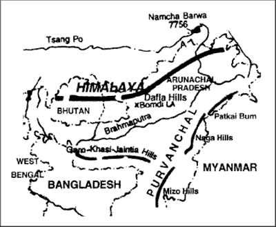
Fig
2: Purvachal
Importance of Himalayas
Climatic Influence :The altitude of the Himalayas, their sprawl and extension intercept the summer monsoon coming from the Bay of Bengal and the Arabian Sea. They also prevent the cold Siberian air masses from entering into India. Had there been no Himalayas, the whole of northern India would have been a desert. The Himalayas are responsible for the splitting of the jet streams into two branches, and these in turn, play an important role in the arrival, success and failure of the monsoons in India.
Defence :Throughout history, the foreign invaders never entered India from the northern side. Despite modern technology of warfare, the Himalayas have great defence value.
Source of Perennial Rivers: Most of the perennial rivers of northern India have their origin in the glaciers, lakes, and springs of the Himalayas.
Source of Fertile Soils :The perennial rivers and their tributaries carry enormous quantities of alluvial soils which are deposited in Great Plains of India.
Generation of Hydro-electricity:
Forest Wealth: There is horizontal zonation of vegetation in the Himalayas. The natural vegetation in the Himalayas varies from the humid tropical to the conifers and alpine pastures. At the higher altitudes are the alpine pastures (margs) used by the tribals for grazing cattle during the summer season.
Orchards, minerals, tourism and pilgrimage
Northern plains:
Youngest
physiographic
feature in India. Depositional flood plain created by Himalayan
rivers
like Indus, Ganga, Brahmaputra and Yamuna.
Densely populated with 30% of worlds population on 10% of worlds agricultural land.
Part
of
the northern plains:
- Babhar – alluvial fans of rivers with course boulders and not suitable for cultivation.
- Khadar – new flood plains with very fertile soil
- Bangar – old flood plains with calcerous kanker formation; less fertile
- Terai – bad drainage
with swampy land.
North
plains
is divided into four parts:
1. Rajasthan plains
· Formed west of Indus.
· Drained by Luni which is located west of Aravalli
· Thar desert is a tropical desert formed due to off shore trade winds and Aravalli range is parallel to south west monsoon so no orographic rains.
2.
Punjab
plains
· Drained by Ravi, Sutlej, Beas
· Khadar plains are present but bad topography causes bad drainage.
3. Gangetic plains
4.
Assam
plains
· Drained by Brahmaputra - the largest river of India by volume.
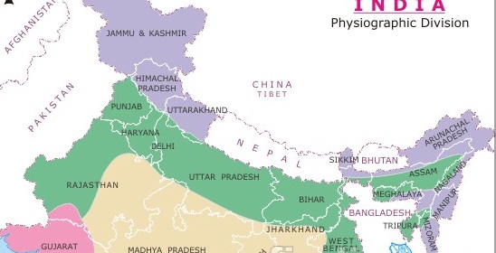
Fig 3: Northern
plain
Peninsular plateau:
It is covered by western ghats and eastern ghats and in the north by the central highlands. The Deccan traps were formed when Indian plate flowed over reunion island. The basaltic flow created layer over layer and it looks like steps. It is higher than northern plains.
Aravalli range: one of the oldest mountain range. It has sedimentary, metamorphosized rocks. Sabarmati from eastern side of Aravali merges into Arabian sea.Vindhyan range: source of many north flowing rivers that meet Yamuna. It represents the water divide of central India. Mahi from north side of Vindhya also is a west flowing river.
Malawa plateau – between Aravalli and Vindhya range.
Satpuda range – has the Amarkantak plateau which is source of Narmada and son.
Meghalaya plateau – Garo, Khasi, Jaintia hills and Barail range in line. The hills aren't very high so ineffective in blocking rain winds. These are blocked at Arunachal Pradesh.
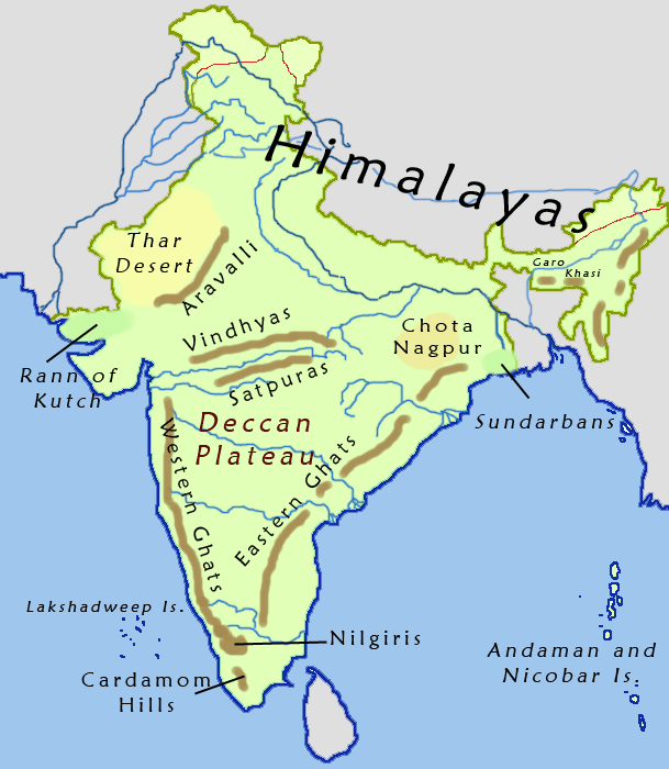
Fig
4: Peninsular plateau
Narmada
and
tapti are old rift valleys. Worlds largest freshwater
lakes are rift
valleys.
Western Ghats: UNESCO World Heritage Site
They
are
extending from Maharashtra to Kerela. In Maharashtra they
are steeper and
higher. In Karnataka they are broader. In Kerela they are
isolated hills with
gaps that allow rain winds to pass through them.
Height
of the Western ghats decreases from north to south.
The
air
parcel that passes over the hills retain energy but as
they take longer the
droplets precipitate into rain.
Anaimudi
is
the highest peak in the Deccan.
Eastern Ghats
Discontinuous
range
but with lower heights in the mountains. Laterite soil is
present.
Coromandel coast lies between eastern Ghats and bay of
Bengal.
Bay
of
Bengal has 572 islands out of which 2 main islets are
richies
and labyrinth island.
Andaman
and Nicobar are separated by the 10° channel and
Lakshadweep
by 11° channel. Barren island in Nicobar is india's only
active volcano.
Southern hill complex:
They
are
not a part of the western or eastern ghats. From north to
south the hills
are:
Nilgiri,
Palani, Anamalai and Cardamom. Palghat pass between Nilgiri
and Anamalai hills.
Nallamala,
Javadi too are hill ranges in the south but above the
above hills.
The western and the eastern ghats meet at Nilgiri hills.
Fig
5: Southern hill complex
Importance of Deccan plateau:
1. Oldest and most stable region.
2. Rich in mineral wealth.
3. 98% of Gondwana coal
4. Peninsular soil is black cotton soil or regur soil. Plantation of tea, coffee, rubber, cashews and sugarcane.
Coastal Plain:
It extends from Rann of Kutch to Sunderbans. It has two parts western coastal plain and eastern coastal plain.
Western coastal plain:
1.
Narrower and steeper
with fast flowing
rivers but no deposits.
2. Rivers form estuaries not deltas.
3. Good for port development
4. Has two gulfs: kutchh and khambat.
5. Coast are two: Konkan and Malabar.
Eastern coastal plain:
1. Broader and with large rivers that form delta.
2. Chilika lake – biggest salt water lake in India.
Solved Question Papers
Q.Consider the following pairs :
Medieval Indian State : Present Region
1. Champaka : Central India
2. Durgara : Jammu
3. Kuluta : Malabar
Which of the above pairs is/are correctly matched? (UPSC CSAT 2015)
1 and 2
2 only
1 and 3
3 only
Ans . B
The ninth century saw the rise of a number of hill states in the Himalayas, some of which maintained their identity until recent years, despite their wars with each other and the frequent raids from the men of the plains.
States such as Champaka (Chamba – Himachal Pradesh), Durgara (Jammu), Trigarta (jalandhar), Kuluta (Kulu – Himachal pradesh), Kumaon and Garhwal managed to remain outside the main areas of conflict in the northern plains.
Q.Consider the following rivers :
1. Vamsadhara
2. Indravati
3. Pranahita
4. Pennar
Which of the above are tributaries of Godavari? (UPSC CSAT 2015)
1,2 and 3
2,3 and 4
1,2 and 4
2 and 3 only
Ans . D
Left tributaries: Purna, Pranahita, Indravati, Sabari, Taliperu, Wainganga, Penganga, Wardha, Dudhana
Right tributaries: Pravara, Manjira, Pedda Vagu, Manair, Kinnerasani
Chapter Review
Score more than 80% marks and move ahead else stay back and read again!