-
Chapter 3: RIVERS OF INDIA
Introduction
THE DRAINAGE SYSTEM
The drainage system is an integrated system of tributaries and a trunk stream which collect and funnel surface water to the sea, lake or some other body of water.
The total area that contributes water to a single drainage system is known as a drainage basin.
A geometric arrangement of streams in a region, determined by slope, differing rock resistance to weathering and erosion, climate, hydrologic variability, and structural controls of the landscape is known as a drainage pattern.
Thus, drainage pattern refers to a design which a river and its tributaries form together, from its source to its mouth.
India has the following drainage patterns:
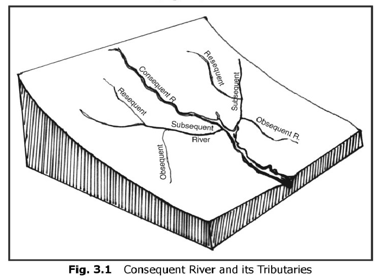
The Antecedent or Inconsequent Drainage: The rivers that existed before the upheaval of the Himalayas and cut their courses southward by making gorges in the mountains are known as the antecedent rivers.
Consequent Rivers:The rivers which follow the general direction of slope are known as the consequent rivers. Most of the rivers of peninsular India are consequent rivers.
Subsequent Rivers:A tributary stream that is eroded along an underlying belt of non-resistant rock after the main drainage pattern (consequent river) has been established is known as a subsequent river. Due to the northward slope of the Peninsula towards the Great Plains, the rivers originating from the Vindhyan and the Satpura ranges flow northward into the Ganga system. The Chambal, Sind, Ken, Betwa, Tons and Son meet the Yamuna and the Ganga at right angles. They are the subsequent drainage of the Ganga drainage system.
Superimposed Epigenetic (Discordant) or Superinduced Drainage :It is formed when a stream with a course originally established on a cover of rock now removed by erosion, so that the stream or drainage system is independent of the newly exposed rocks and structures.
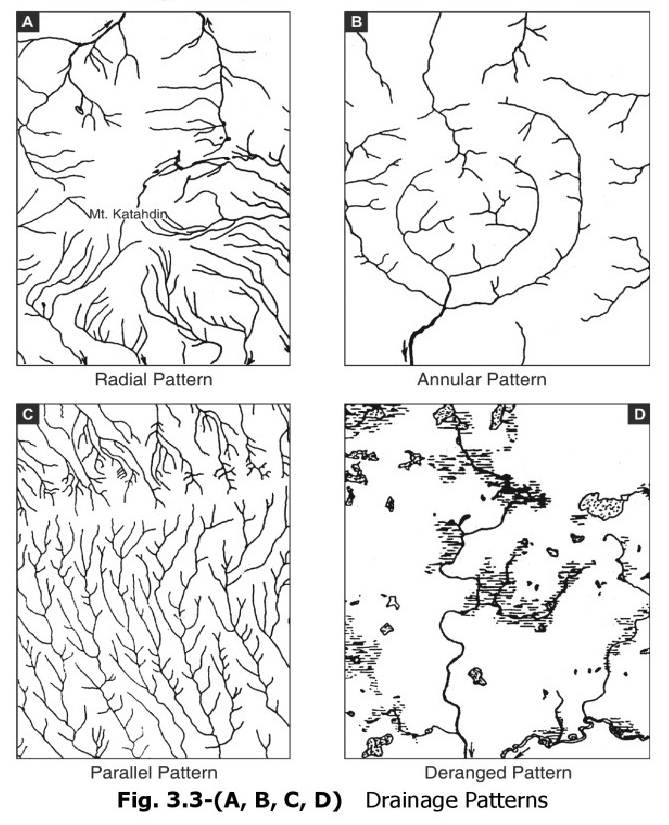
Dendritic Drainage:A term used for drainage which is branching thereby giving the appearance of a tree. Most of the rivers of the Indo-Gangetic Plains are of dendritic type
Trellis Drainage:Trellis is a rectangular pattern formed where two sets of structural controls occurs at right angles. In a trellis pattern, the river forms a net like system and the tributaries flow roughly parallel to each other.
Barbed Pattern:A pattern of drainage in which the confluence of a tributary with the main river is characterized by a discordant junction-as if the tributary intends to flow upstream and not downstream.
Rectangular Drainage:The drainage pattern marked by right-angled bends and right-angled junctions between tributaries and the main stream is known as rectangular drainage.
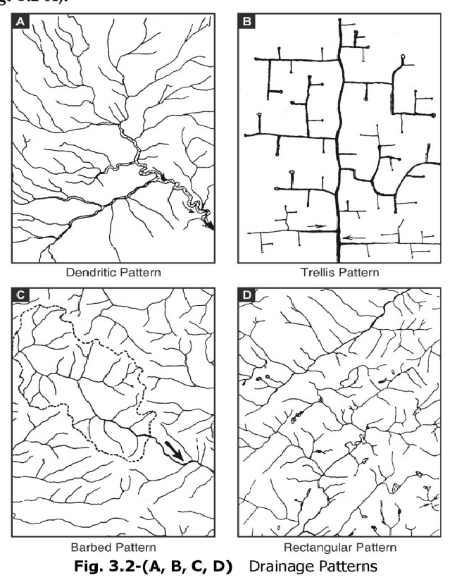
Radial Pattern:It is a pattern characterised by outflowing rivers, away from a central point, analogous with the spokes of a wheel. It tends to develop on the flanks of a dome or a volcanic cone.
Annular Pattern:In this drainage pattern, the subsequent streams follow curving or arcuate courses prior to joining the consequent stream.
Parallel Drainage:The drainage pattern in which the rivers flow almost parallel to each other is known as parallel drainage.
Deranged Pattern:This is an uncoordinated pattern of drainage characteristic of a region recently vacated by an ice-sheet.
Indian rivers are of two
categories: northern rivers and peninsular rivers.
Northern rivers:
Indus:
It has 5 tributaries Chenab,
Ravi, Beas, Satluj and Jhelum. Chenab is the largest. The Indus is one of the most important drainage systems of the subcontinent of India. It has a
length of 2880 km, of which 709 km lies in India. The catchment area of the Indus is about 1,165,000
sq km, out of which about 321,284 sq km is in India.
Satluj is the only one that
doesn't originate in India.
Ravi, Beas, Satluj, Chenab and Yamuna flow through Himachal Pradesh.
Jhelum (Vitasta):
1. Srinagar is on banks of Jhelum. It is the most important river of Kashmir.
2. Rises at Verinag
Chenab (Asikni):
1. Two headward tributaries: Chandra and Bhaga
Ravi (Parushni or Irawati):
1. Source near Rohtang pass in Himachal Pradesh
Beas (Vipasa or Argikiya):
1. Source near Rohtang pass in Himachal Pradesh
2. Entirely within India.
Satluj (Satadru or Satudri):
1. Originates near Mansarovar.
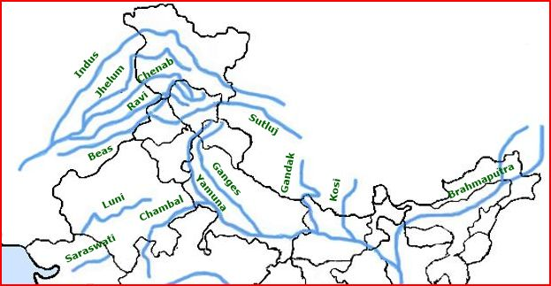
Fig 1: Indus river system
Ghaggar (the legendary Saraswati)
This is an inland drainage which rises in the talus fan of the Shiwaliks of Sirrnur near Ambala (Haryana),
After entering the plains, it disappears, but reappears at Kamal District
At present, the entire area is practically a desert, and the Ghaggar-Hakra are practically ephemeral streams coming into flow only during the season of general rains.
Ganga:
Originates as
Bhagirathi from Gangotri. The
river is home to more then 140 fish species, 90 amphibian species and the endangered Ganga
river- dolphin.
Left
bank tributaries: Kosi, Ramganga, Gandhak, Gomati, Gaghar.
Right
bank tributaries: Yamuna, Son, Hugli
The Yamuna River(length 1380 km)
This is the longest and the western-most tributary of the Ganga. Its source lies in the Yamunotri Glacier On the western slopes of Banderpunch
It joins the Ganga at Allahabad.
The important tributaries Of the Yamuna are mostly the right bank tributaries originating from the Aravallis, Vindhyan Range and the Malwa Plateau of Madhya Pradesh. The Chambal, Sind, Betwa, Ken and Tons are the main righthand tributaries of the Yamuna River.
The Chambal (length 960 km)
The Chambal River is famous for its extensive ravines which it has carved along in the lower Chambal Valley.
Brahmaputra:
Originates in Kailash and enters into India as Dibang. Through the Malda gap between Rajmahal and Garo hills passes into Bay of Bengal. Enters Bangladesh and is known as Jamuna. Meets Ganga and is now called Padma. Then meets Meghna river and is called Meghna. Forms a large delta.
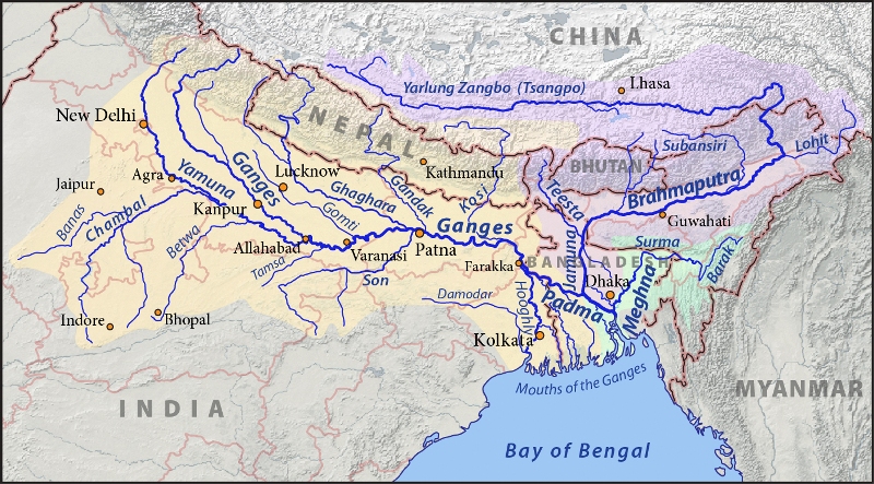
Fig 2: Ganga and
Brahmaputra
Peninsular rivers:
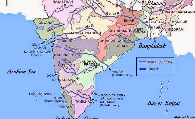
Fig 3: Peninsular rivers
East flowing rivers: kaveri, godawari, krishna, meghna, tungabhadra, mahanadi, damodar, subarnarekha.
Damodar – source in chota nagpur plateau.
Godawari – dakshin ganga
Krishna – source near mahabaleshwar.
Mahanadi – hirakud dam
Rushkiya river – mouth of river is hatching site for olive ridley turtles.
Olive ridley turtles- the most abundant sea turtles in the world. Live in warm waters of pacific, atlantic and indian ocean. Odissa coast is the largest mass hatching site for olive ridley turtles.
West flowing river: Narmada and Tapti. These rivers form no delta as they dont carry any alluvial sediments.
Physiographic Divisions of the Great Plains of India
The Great Plains of India are a remarkably homogeneous surface with an imperceptible slope. They are a featureless alluvial fertile plains formed mostly by the depositional process of the Himalayan and Vindhyan rivers.
The Northern Plains of India may be divided into the following sub-regions:
The Bhabar Plain: It is highly porous tract of land where small streams disappear into the soil and only large streams survive. This tract isn't suitable for the survival of crops and thus only big trees grow here that have long roots. The inhabitants of these regions are the cattle herders (Gujjars)
Tarai tract: It is a marshy tract. However it has been mostly reclaimed for agriculture.
The Bhangar (Bangar) Plains:These are upland alluvial tracts of the Great Plains of India, formed by the older alluviums. The Bhangar land lies above the flood limits of the rivers. The soil is dark in colour, rich in humus content and productive. It contains concretions and nodules of impure calcium carbonate or 'Kankar'. In relatively drier areas, the Bhangar also exhibits small tracts of saline and alkaline efflorescences known as 'Reh', 'Kallar' or 'Thur'. Bhangar is generally a well drained and the most productive land of the Great Plains of India.
The Khadar Plains: The new alluvium tracts along the courses of the rivers are known as the 'Khadar' or 'Bet lands. The khadar tracts are enriched by fresh deposits of silt every year during the rainy season.
Brahmaputra Plain
It is the eastern part of the Great Plains of India. It is a depositional plain, that is surrounded by water from all three sides.
The Assam Valley is characterised by a steep slope along its northern margin but the southern side has a gradual fall from the Meghalaya Plateau. The whole length of the plain is traversed by the Brahmaputra. Due to the low gradient, the Brahmaputra is a highly braided river having numerous islands.
Majuli (area 930 sq km) is the largest river island of India and the second largest in the world after the Marajo Island of the Amazon River.
The Indian Islands
India has a total of 615 islands, of which 572 lie in the Bay of Bengal, and the remaining 43 in the Arabian Sea.
The Bay of Bengal islands include the Andaman and Nicobar Islands which are largely tectonic and volcanic in origin, while the islands of the Arabian Sea are mainly coral formations.
One of the largest and also the rarest crabs in the world, the Giant Robber Crab, can be found in the Wandoor Marine Biosphere Reserve in south Andaman and Great Nicobar Islands. Its powerful claws help it to climb the coconut tree and break the hard shell of its fruit.
Lakshadweep islands are separated from the Maldive Islands by the Eight Degree Channel.
The Andaman Islands have been formed by the extension of the Tertiary mountain chain of Purvachal. The physiography of the Nicobar islands is mainly of coral origin.
RIVER REGIMES
The pattern of the seasonal flow of water in a river is called its regime. The main difference in the flow pattern of the Himalayan and the Peninsular rivers is caused by the differences in climate.
The Himalayan livers are perennial and their regimes are dependent on the pattern of water supply both from snow-melt and rainfall. Their regimes are monsoonal as well as glacial.
The regime of most of the peninsular rivers, on the other hand, are only monsoonal as they are controlled by rainfall alone.
Major Rivers of Peninsular India
| River | Source | Length in km | Main tributaries |
|---|---|---|---|
| Godavari | Trimbak Plateau Near Nasik {Maharashtra) | 1465 | Manjra, Penganga, Wardha Wain ganga, Indravati, Saban, Pranhita |
| Krishna | Near Mahabaleshwar (Maharashtra) | 1400 | Koyna, Ghataprabha, Malprabha, Bhima, Tungbhadra, Musi, Muneru |
| Narmada | Arnarkantak | 1310 | Hiran, Orsang, Barna, Kolar, Burhnar, Tawa, Kundi |
| Mahanadi | Dandakaranya Plateau near Raipur | 857 | Ib, Mand, Hasdeo, Seonath, Ong,Jonk, Tel |
| Kaveri | Taal Kaveri | 800 | Herangi, Hernavati, Lokpavni, Shimsa, Arkavati, Kabani, Bhavani, Amravathi |
| Tapi | Multai in Betul Dist, (M.P.) | 730 | Puma, Betul, Patki, Ganjal, Dhatranj, Bokad, Amravati |
Comparison of the Peninsular and the Extra-Peninsular Rivers
| Peninsular | Extra-Peninsular (Himalayan) |
|---|---|
| The rivers of Peninsular India are much older. Some of them are as old as the Pre-Cambrian Period. | The rivers of the Extra-Peninsular India are much younger with few exceptions like Indus, Ganga |
| They are mostly consequent or rejuvenated rivers. | Inconsequent rivers mostly |
| small basins except for godavari | large basins |
| The channels of these rivers are broad. | The channels of these rivers in the upper courses form gorges, waterfalls, and rapids. |
| Negligible vertical erosion | Significant vertical, lateral erosion |
| Slow moving, low carrying capacity, mainly depositional agents | Swift movements, transport huge quantity of sediments, active erosional and depositional agents. |
| Shallow meanders, non navigable, seasonal nature | Make sharp meanders and ox bow lakes, navigable in plains, perennial nature. |
| Originate in western ghats | Himalayan origin |
| Make deltas and estuaries. | These rivers make only deltas. The Sundarban Delta is the largest in the world. |
Solved Question Papers
Q.Which of the following is/are tributary tributaries of Brahmaputra?
1. Dibang
2. Kameng
3. Lohit
Select the correct answer using the code given below. (UPSC CSAT 2016)
1 only
2 and 3 only
1 and 3 only
1, 2 and 3
Ans . D
Brahmaputra’s main left bank tributaries, viz., Dibang or Sikang and Lohit
the important right bank tributaries are the Subansiri, Kameng, Manas and Sankosh.
Q.In which of the following regions of India are shale gas resources found?
1. Cambay Basin
2. Cauvery Basin
3. Krishna-Godavari Basin
Select the correct answer using the code given below. (UPSC CSAT 2016)
1 and 2 only
3 only
2 and 3 only
1, 2 and 3
Ans . D
Q.Recently, linking of which of the following rivers was undertaken (UPSC CSAT 2016)
Cauvery and Tungabhadra
Godavari and Krishna
Mahanadi and Sone
Narmada and Tapti
Ans . B
Andhra Pradesh Government has succeeded in interlinking Krishna-Godavari rivers through the Pattiseema lift irrigation scheme and 10,000 cusecs of water from the Godavari was being presently drawn on a daily basis through the project to meet the requirements of the Krishna delta.
Q.Recently, which of the following States has explored the possibility of constructing an artificial inland port to be connected to sea by a long navigational channel? (UPSC CSAT 2016)
Andhra Pradesh
Chhattisgarh
Karnataka
Rajasthan
Ans . D
Rajasthan wants to develop artificial inland shipping port at Jalore, it’ll be connected to the Arabian Sea by developing a channel along the Kutch Creek.
Q.Consider the following rivers:
Barak
Lohit
Subansiri
Which of the above flows / flow through Arunachal Pradesh? (UPSC CSAT 2014)
1 only
2 and 3 only
1 and 3 only
1, 2 and 3
Ans . B
The Barak is an important river in Manipur and Mizoram
The barak river , the head stream of Meghna rises in the hills in Manipur”
Q.Which one of the following pairs of islands is separated from each other by the ‘Ten Degree Channel’? (UPSC CSAT 2014)
Andaman and Nicobar
Nicobar and Sumatra
Maldives and Lakshadweep
Sumatra and Java
Ans . A
The Andaman in the north and the Nicobar in the south are separated by a water body called 10 degree channel
Chapter Review
Score more than 80% marks and move ahead else stay back and read again!