-
Chapter 6: WATER RESOURCES
Introduction
Rain, rivers, lakes, ponds are important source of water in India.
India receives 2nd highest rainfall for a country of its size. 1st is Brazil.
Water availability is 2000 cum/person/year and by 2050 it will be 3500 cum/person/year but availability shall be 1200 cum/person/year.
Rivers are also important water source. The Himalayan and peninsular rivers are the two types of rivers.
|
Himalayan River |
Peninsular river |
|
Perennial |
Seasonal |
|
Antecedent |
Superimposed |
|
Flood prone |
Not flood prone |
|
Large, huge flood plain, low slope and forms meander. |
No shifting of course – due to hard rock surface, no shifting of course, small catchment area. |
|
Easily navigable |
Waterfalls at any course |
|
Can be diverted for irrigation |
Can’t be diverted for irrigation without pumps as river basin located on higher plateau |
|
Waterfalls at youthful stage only |
Waterfalls at any stage |
TABLE 1: HIMALAYAN AND PENINSULAR RIVER
Groundwater resources:
Aquifer is the storage pool for groundwater. It stores rainwater that percolates through the soil or cracks. When all pores are filled it’s called saturation zone. Upper layer of the saturation zone is called water table.
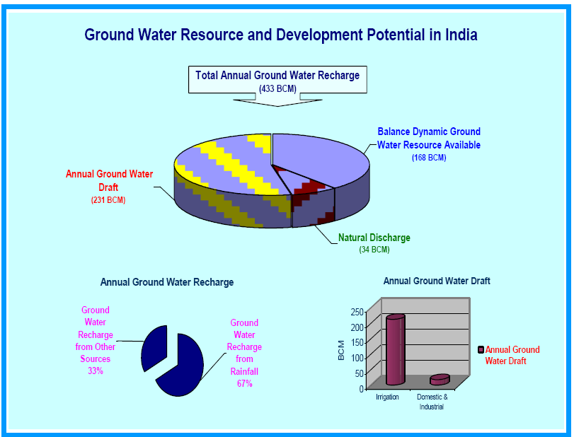
Groundwater capacity of India is 30-40 million hectares. It is found in selected locations only:
- Northern alluvial plains. Peninsular river basins and deltas of rivers.
- Bhabhar [foothills of the Himalayas]
- Eastern and western coastal plains
- Peninsular granite and gneissic rocks.
Ganga rivers groundwater reserve is highest at 17 million hectares. Indus river has a ground water usage rate of 80%.
India’s groundwater use is more than the replenishment rate and so aquifers are drying up. 60% of India's irrigation through tube wells and dug wells. This hurts the water resources. Also unplanned urbanization, increasing population, overuse affect it.
Flouride, arsenic, nitrate fertilizers are affecting underground water resources.
Watershed:
Geo hydrological unit that drains at a common point. E.g: A main river and its catchment area.
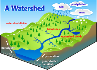
Fig 3: Watershed
In watershed management we construct small check dams to stop flow of water so it can percolate. No large dams and no stopping of the river flow.
Afforestation on river banks, soil conservation are other methods.
Drought-prone area Program + Desert development program + integrated wasteland development program = Integrated watershed Management Program under the department of land resources, ministry of rural development.
Watershed management can work successfully under community participation, decentralization and strong Panchayati Raj system.
TYPES OF LAKE'S
A lake is a natural depression filled with water. They also help in the prevention of sudden floods and droughts. The lakes of India have different origins. Some of the important lakes of India have been described briefly in the following section:
The Tectonic Lakes:These are formed due to the fractures and faults in the earth's crust.
The Crater Lakes:Crater lakes are formed when the craters and calderas are filled with water.
Glacial lakes:These lakes are the result of glacial erosion
Fluvial lakes:Fluvially originated lakes are generally temporary and are soon obliterated.
Aeolion lakes:These are small temporary hollows or depressions lying on the wind blown sand surface.
Dissolution lakes:These lakes are formed due to a depression of the surface by underground dissolution of soluble rocks like limestone and gypsum.
Lagoons:These are formed by deposition of sandbars along the sea coast.
Landslide lakes:These lakes are produced by landslides and rock-falls causing obstruction in the course of streams.
| River | Description |
|---|---|
| Bhimtal | Situated near the town of Bhimtal in Kumaun Divison of Uttarakhand, it is a fascinating lake with an island in the centre. |
| Chilka Lake | It is the largest coastal lake in India. The lake was formed due to the silting action of the Mahanadi River which drains into the northern end of the lake. |
| Dal Lake | Dal is a famous lake in Srinagar. |
| Kaliveli Lake | The lake is one of the largest wetlands in the peninsular India. |
| Kolleru Lake | The lake was an important habitat for an estimated migratory birds such as Grey or Spot-billed pelicans. Rich in flora and fauna, it attracts birds from Siberia and eastern Europe between the months of October and March. |
| Loktak Lake | It is also called the only 'Floating Islands Lake' in the world due to the floating Phundis (floating islands) on it. |
| Sambhar Lake | It is the largest salt lake of India. |
Chapter Review
Score more than 80% marks and move ahead else stay back and read again!