-
Chapter 10: TYPES OF CLOUDS
Introduction
- Types of clouds:
- High clouds:
- Cirrus: indicate fair weather and good sunset. Look fibrous or wispy.
- Cirrocumulus: Appear like white globular mass.
- Cirrostratus: resemble thin white sheet or veil.
- Medium clouds:
- Altocumulus: indicate fair weather.
- Altostratus; dense, grayish clouds
- Low clouds:
- Stratocumulus: rough, bumpy cloud
- Stratus: Brings dull weather with light drizzle.
- Nimbostratus: Rain clouds. It also brings snow or sleet.
- Clouds with great vertical height:
- Cumulus: Typically seen in tropical, humid regions.
- Cumulonimbus: Thunder cloud brings rain with thunder and lightning.
Phenomenon caused by High Humidity
Haze: It is caused by smoke or dust in industrial areas or when there is unequal refraction of light in air of different densities in lower atmosphere. This is seen in regions of low humidity [Relative humidity < 75%].
Mist: It occurs in areas of high humidity where relative humidity is 75% +. Condensation of water vapor in air causes small water droplets to float about in lower atmosphere forming clouds.
Fog: These are formed when water vapors condense on smoke or dust particles. A dense ground cloud is formed reducing visibility. Although fogs are seen in tropics and temperate areas, they are denser in high and middle latitudes than tropics. Fogs are more common over seas than land and prevalent in coastal areas.
Haze and Mist occur more commonly in dry interiors.
Clouds and their types
Low altitude clouds:
1. Nimbostratus – rain bearing
2. Stratocumulus and cumulus are fair weather clouds.
Middle altitude clouds:
1. Altocumulus
2. Altostratus
High altitude clouds:
1. Cirrostratus, cirrocumulus and cirrus.
Clouds with vertical development are cumulonimbus which is stormy clouds and an indicator of cyclonic heavy rainfall.
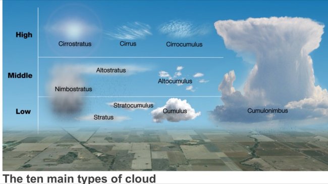
Fig 1: Types of clouds
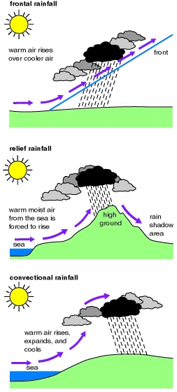
Rainfall and its types
The term "rainfall" is used to describe precipitation in the form of water drops of sizes larger than 0.5 mm. Other forms are snow, drizzle, glaze, sleet and hail.
Types of rainfall:
1.
Frontal
and
cyclonic - Seen in temperate regions and is
reason for rainfall during winters there. Warm air
rises over cool air and is cooled due to it. this leads to
condensation and rain.
2.
Convectional
- Hot air formed due to sun's heating effect on
oceans rises upwards and condenses. This rain is seen in equatorial
and tropics.
3.
Orographic
- This is seen where moist air is forced to climb a mountain barrier. The windward sides of mountains see this rainfall. It is also called “Relief rain”. The leeward side of mountain however doesn’t receive much rainfall and are called “Rain shadow regions”. E.g:
Western ghats
Pressure systems of the world:
Entire earth is divided into four pressure belts. Belts aren’t continuous but pockets of low or high pressure. Low pressure is created by heat and rising movement of air. High pressure is created by low temperature and descending air.
The belts are:
1. Equatorial low pressure belt.
2. Sub tropical high pressure belt
3. Sub polar low pressure belt
4. Polar high pressure belt.
Equatorial low pressure belt OR inter tropical convergence zone:
The direct insolation leads to low pressure as the air is heated. The heated air rises upwards and condenses to bring evening rain.: The region along the equator and within 5 degree North and South is the equatorial low pressure belt is called Doldrums.
This convectional rain is common throughout the year in equatorial areas.
Calm belt with slow winds.
Sub tropical high pressure belt:
The air above the equator moves towards the poles but due to Coriolis force it is deflected and its path increases. The air loses energy and cools down; it descends and creates a high pressure belt.
Sub polar low pressure belt:
The cold air from the poles moves to the equator but the warm air of the sub tropic high pressure zone collides with it. The warm air rises here and creates a low pressure zone. About 30 degree North and South is the area of descending air currents or wind divergence or anticyclones. These are the horse latitudes. 60 degree North and South are the temperate low pressure belts and zones of cyclonic activity. Then at 90 degree north and south are the polar high pressure belts.
Polar high pressure belt:
The air from the low pressure sub polar belt descends here creating high pressure. Also the low temperature cools air.
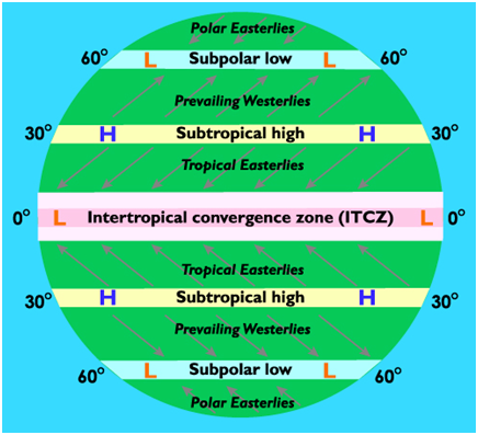
Fig 3: Pressure belts
These winds blow in the same direction throughout the year. But due to Coriolis force their direction is deflected. Winds tend to blow from high pressure belts to low pressure but due to Earth’s rotation are deflected to right in north hemisphere and left in south hemisphere - “Ferrel’s law”. Coriolis force to is absent at the equator but increases towards the poles. Due to large expanse of oceans in the Southern hemisphere compared to North, planetary winds blow harder.
Trade winds or Easterlies:
They blow from sub tropical high to the equatorial low. They are deflected from east to west due to Coriolis force.
Desert winds:
The trade winds blow from east to west. But they lose moisture as they pass over the continents. The western margins of the continents don’t receive rain. Hence deserts are formed called trade wind deserts.
The second reason for deserts is they are on contact with cold currents that reach the western margins of the desert. These cold currents create a desiccating effect on the trade winds.
Westerlies:
They blow from sub tropic high pressure zone to sub polar low pressure zone. Their direction is from west to east due to Coriolis force. Due to absence of land mass in southern hemisphere they have high velocities.
Polar easterlies:
Blow from Polar Regions to sub Polar Regions. Direction is east to west.
Seasonal winds:
These are monsoon winds in Indian subcontinent. The easterlies blow from north to south in winter and south to north in summer over some areas only.
The reason is earth tilted axis which causes apparent movement of the sun in the north during June - July. This causes shifting of the low pressure belt or ITCZ to the north.
This brings rainfall to India.
Land and sea breezes:
During the morning the sea gets heated slower than land. The land remains under low pressure and sea is high pressure. Thus we get sea breeze. In the night the land cools faster than sea due to lower specific heat. This creates low pressure over sea and the high pressure over land. Hence we get land breeze.
The fishermen use this system to move from land to sea and back.
Upper troposphere winds:
The troposphere has a different situation than at land. Here there is high pressure over the equator and low over the poles. They blow from west to east “Westerlies”. In these winds there are strong, narrow band of winds called Jet Streams [speed – 300 kmph].
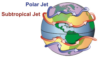
Fig 4: Jet streams
Cyclones
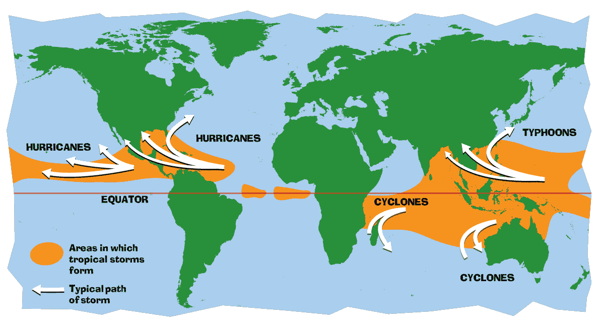
Fig 5: Cyclone map
Tropical cyclones:
8-20° latitude. Movement from east to west. They are created due to thermal conditions. Their path is difficult to predict. They have winds of high speed but quickly dissipate on land. They mostly affect coastal areas.
Location: Bay of Bengal, western pacific i.e. Philippines etc and Gulf of Mexico when formed over these areas they make landfall hence the coastal parts of these areas are largely affected.
The other regions where they are formed but can’t make landfall are Arabian sea, east coast of Africa, west coast of Mexico and south west USA.
Formation:
1. The increase in the sea surface temperature causes air to warm and rise. This air also has moisture. The low pressure zone at sea level is where air converges.
2. As air moves upwards the Coriolis force causes spiral movement. After reaching the top it dissipates.
3. Continuous process of above causes a cyclone where a high pressure eye is surrounded by low pressure region. But as this cyclone is fueled by moisture when it makes landfall it dissipates quickly. This is due to being cut off from moisture.
Temperate cyclones:
30-40° latitude. Movement from west to east. They are formed due to movement of air [rising]. They have winds at 40-50 mph. They don’t dissipate quickly and cause destruction.
They are located on the western coast of USA and Europe. They are influenced by the Westerlies.
Chapter Review
Score more than 80% marks and move ahead else stay back and read again!