-
Chapter 12: CLIMATIC REGIONS OF THE WORLD
Introduction
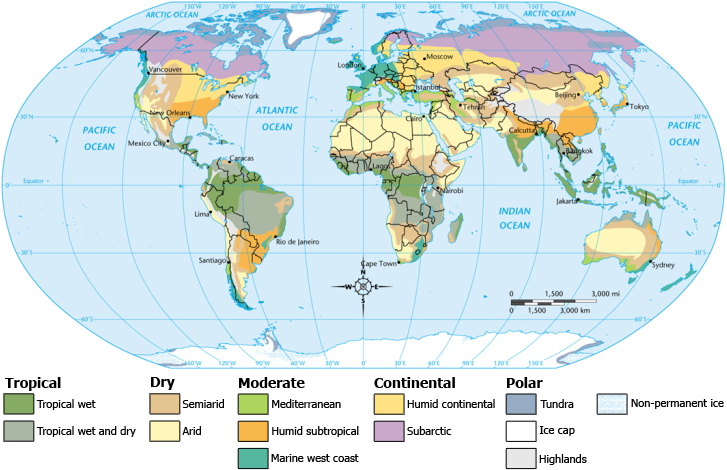
Fig 1: Climate map
Equatorial Region:
Between 5 and 10 ° North and South of the equator. The temperature is uniform throughout the year with no variations. Cloudiness and heavy precipitation make the climate bearable. The annual range of temperature is small and so is the diurnal range of temperature [ range of temperature in a 24 hour period]. Rainfall is heavy and throughout the year with no dry period. The equinoxes coincide with the periods of maximum rainfall [April and September].
- Morning is bright and sunny.
- Afternoon sees heavy convectional rainfall accompanied by lightning and thunder.
- Relative humidity is high and weather feels sticky.
- Equatorial vegetation has features like:
- Growing season throughout the year.
- Great variety of vegetation
- Trees are tall as they compete for sunlight. Undergrowth is less as sunlight may not reach the ground.
- Tropical and equatorial forests have large number of species in a small area and this makes commercial exploitation tough. Also the hardwood doesn’t float on water and is difficult to transport. Thus most of these nations are net importers of timber.
Oil palm, cocoa and rubber are the main crops.
Hot
and
wet climate throughout the year. Rainfall during evening and
high biodiversity. Intense competition amongst species for
survival. Large number of species in a small area which makes it
tough for exploitation. Presence of many epiphytes.
Also
the trees are hardwood and difficult for transportation by
rivers. Hence most of these regions are importers of timber.
Living
conditions
are poor because of hot and moist climate. High incidents of
disease. Death rates are higher in equatorial and tropical
regions due to the pathogens finding it easier to spread in
moist weather then the dry weather in deserts.
Deserts of the World
Deserts
Deserts occupy 1/5th of the World’s land. They are almost always present in 15-30 degree parallel both north and south of the equator. They lie in the trade wind belt in the western margin of continents and hence receive offshore trade winds. They are also bathed by cold currents that have a desiccating effect on the moisture and hence it doesn’t precipitate.
Types of deserts:
- Trade wind deserts
- Continental interior desert / mid latitude desert – they have extreme temperatures.
Desert landscapes:
- Rocky deserts
- Stony deserts
- Sandy deserts
- Badlands
- Mountains deserts
Landforms in the dessert are formed due to chemical actions of minerals present in rain water on the rocks [weathering], rapid heating and cooling of rocks due to high temperatures. Water is expanded on heating in the morning and contracts at nights due to low temperature. This also weathers the rocks. Wind effects are also high here as there is no presence of vegetation to block the winds.
Tropical Deserts:
They are present between 15-30 degree latitudes in western margin of continents. They receive offshore trade winds hence low precipitation. Also they are basked with cold currents which have a desiccating effect on the winds.
The deserts are present on leeward side or rain shadow side of mountains. Hence they experience low rainfall.
Low
population
and xerophytic vegetation. However compared to temperate deserts
the annual temperature range is low. Deserts also have high
diurnal temperature range i.e. day and night temperatures have
high difference.
Desert plants have long roots and thorns in place of leaves to prevent evaporation. Cacti are plants that store water in the stems to withstand long droughts.
Nomadic herders like Bedoiuns [Sahara] and Bindibu [Aborigines of Australia] tribes are seen in deserts. Tuaregs and Gobi Mongols are nomadic horsemen who have settled here.
Continental deserts:
These are located in interior region. The rain bearing winds don’t reach here. They have high annual temperature range than tropical deserts..
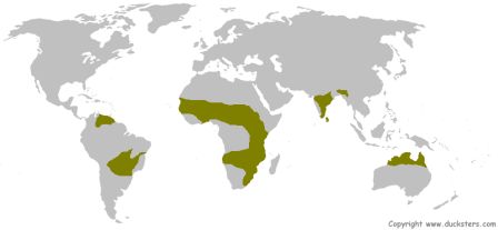
Tropical Grasslands: Savannah
Savanna Climate:
Transitional type of climate found between the hot trade wind deserts and the equatorial forests. There is a distinct cool, dry and hot, wet seasons here. In days the clear sky and the treeless land ensure that the temperatures are high and similarly the night time temperatures are low due to the radiation of heat from the land. Thus the high diurnal temperature range is a characteristic feature of the savannas.
Tall grass and short trees are the features of savanna forest. Trees are mainly deciduous origins. Wildlife is plenty. Masaai [nomadic, cattle herders] and Hausa [settled cultivators] are the tribes found there.
The Sudan climate is also responsible for rapid deterioration of soil fertility. The torrential rains cause heavy leaching of minerals like nitrates, potassium and phosphates. Then in the summer the high evaporation rates water of the soil dries up and so the savanna regions have laterite soils. These can’t have good yield unless proper fertilizer treatment is given.
Temperate grasslands: Steppe
These are practically treeless grasslands in the interiors of the continents. They are remotely located and are far away from the influence of any moisture bearing winds.
In Northern hemisphere these are the Steppes and the Prairies, in the Southern hemisphere they are Pampas, Velds and Downs. In the northern hemisphere , these grasslands face extreme heat in summer and extreme cold in winter.
This is due to being far away from the moderating influence of the sea. In Southern hemisphere, due to moderating influence by the oceans extreme temperature swings are absent. Rainfall is mild in north compared to south.
Wheat cultivation is the major occupation in the prairie grasslands. But due to the large landholdings one characteristic feature of the agriculture is poor yields. This is due to low attention that can be paid by a farmer compared to those who have small land holdings.
However due to sparse population majority of the wheat is exported and so the Prairies are called the Granaries of the World. 75% of Canadian wheat is exported to European nations that though have higher yield but can’t feed their dense populations.
Wheat has two types:
- Summer wheat: This is grown in parts where winter temperatures are too low and so seedlings are sown in summer. This wheat is used for making cakes, biscuits and pastries as it is too soft for bread making. 25% of wheat produced is of this type.
- Winter wheat: 75% of wheat is of this type. It is sown in winter and dried in summer and so becomes hard. This is best for making breads.
- Sherry – Spain
- Port wine – Portugal
- Chianti, Asti, Marsala – Italy
- Champagne, Burgundy, Bordeaux - France
- Conical shape – Snow falls to ground
- Thick, needle shaped, leathery leaves - check excess transpiration. Due to the evergreen nature of trees there is little leaf fall, also low temperature means decomposition rate is less plus the needle shaped leaves are slow to decompose. Podzolized soils of coniferous forests are acidic and hence humus content of soil is low. Thus coniferous forests have low undergrowth.
1 only
2 only
Both 1 and 2
Neither 1 nor 2
Westerlies flow between latitudes 30-60 degrees North and 30-60 degrees South.
The western cyclonic disturbances are weather phenomena of the winter months brought in by the westerly flow from the Mediterranean region. They usually influence the weather of the north and north-western regions of India. They are a non-monsoonal precipitation pattern driven by the Westerlies.
Savannah
Equatorial
Monsoon
Mediterranean
Equatorial climate is characterized by consistently high temperatures (around 30 °C), with plentiful precipitation (150–1,000 cm), heavy cloud cover, and high humidity, with very little annual temperature variation. Wet equatorial regions lie within about 12° latitude of the Equator.
Tropical Monsoon and Tropical Marine:
The basic cause of monsoon climate is the difference in the rate of heating and cooling of the land and sea. The summer sees intense heating of the tropic of cancer region which is the Tibetan plateau; the heating causes a zone of low pressure to develop there.
At the same time in southern hemisphere there is winter and a high pressure belt is formed around the Continent of Australia. The winds blow from high pressure to low pressure and they are attracted to the Indian subcontinent which they reach as the “Southwest Monsoon”.
The conditions are reversed and in the winter a high pressure zone develops in the Central Asian region. The winds blow from there to the low pressure belt in Australia created by intense heating as the sun is now over the Tropic of Capricorn. These winds arrive to Australia as the North west monsoon.
Thus, Tropical Monsoon climate is characterized by the seasonal reversal of winds.
Seasons:
Cool and Dry winter:
The high pressure belt over Central Asia leads to out blowing dry winds. These cause some cyclonic showers over North West belt of India. These winds then cross the Bay of Bengal and acquire some moisture. This moisture causes precipitation over the Southern tip of India which is the Andhra Pradesh, Tamil Nadu region.
Hot, dry summer:
This period sees intense heating of the Indian subcontinent and no precipitation is seen. This lasts from March to May.
Mid June to September:
This is the rainy season in the subcontinent and during this period almost all of the precipitation is seen. Heavy and concentrated rainfall is a characteristic feature of Tropical Monsoon climate.
Tropical Marine climate:
This occurs in the Eastern coast of Tropical countries. They receive rainfall from onshore trade winds continuously throughout the year. The pattern of rainfall is that a peak is seen during the summer which lasts for 4 months. However these regions are also affected by tropical cyclones, hurricanes and tycoons.
Tropical monsoon forests:
These are deciduous due to the presence of a dry period in the rainfall. Thus the leaves are shed. The monsoon forests are less thick and have far fewer species in an area compared to equatorial forests. This also means that they can be commercially exploited for timber. The tropical countries are major producers of timber for the world.
Agriculture is main occupation of most people and the main crops are rice [most characteristic crop of monsoon and marine regions], sugar cane [commercial cash crops], jute [grown mostly along the Ganga - Brahmaputra delta], tea, coffee.
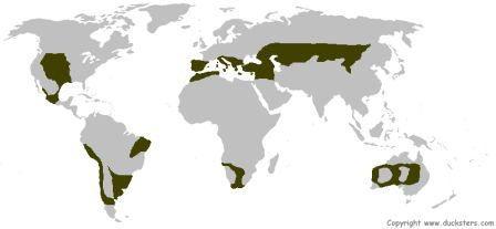
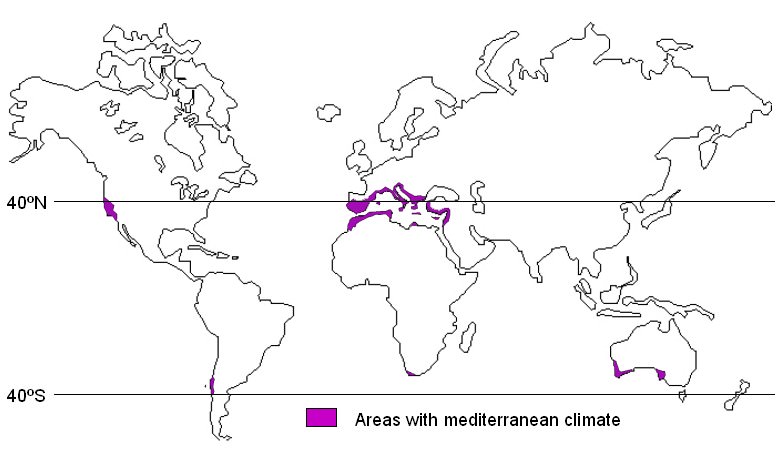
Western margin of temperate areas: Mediterranean Climate
These are regions found in the western margins of continents between 30-45 degree North and South of the equator. Basic cause for this type of climate is the “Shifting of Wind Belts”.
Climate
In summer there is a dry, warm period. Due to the movement of the sun to the top of the tropic of cancer, a warm zone or low pressure region is built on the Mediterranean region and so rain bearing winds are not seen here. But offshore trade winds blow here which don’t bring much precipitation.
Wet winter is a characteristic feature of these regions. The precipitation is brought by the westerly which are onshore. The Wet Winters are a unique characteristic of this region. However this affects the grassland as a cold wet season isn’t favorable for growth of grass and it is thus wiry and bunchy and unsuitable for animal farming. Due to these reason cattle herding isn’t practiced here and Mediterranean regions are Net importers of Dairy products.
Citrus fruit cultivation is practiced here and this region is responsible for majority of the World’s exports. Olive trees can also grow here as it can survive long spells of dry seasons due to its long and deep roots. Since animal fats are scarce here olive oil is the main source for cooking oil.
Grape cultivation or viticulture is practiced here commercially. A long dry summer is most suitable for grape cultivation. Almost 75% of the World’s wine production comes from here.
Famous wines:
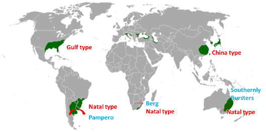
Eastern margin of temperate areas:
Warm moist summer and cool dry winter is seen in this region. These regions occur in the Eastern margins of continents present in the temperate regions. The regions see high annual temperature range.
Due to South East monsoon there is rainfall in summer and North West monsoon leads to rainfall in winters. Typhoons occur in late summer and are disastrous.
In the Gulf of Mexico region of USA there are hurricanes or thunderstorms in summer and local intense heating in winters creates highly destructive tornadoes. This region is also known as the “Tornado Alley”.
The China type climate is modified in the Southern hemisphere due to the moderating influence of the Oceans. The annual temperature range is lower. Hurricanes or typhoons are absent but less destructive weather activity is seen here too.
Natural vegetation is evergreen as rainfall is throughout the year and no dry period is present. The adequate rainfall has made this region the most productive and intensively cultivated region.
Rice is the main crop of China and Eastern margin countries of Asia. Since rice isn’t the staple food of the gulf states , they grow corn and maize, cotton and tobacco. The Corn belt of USA accounts for half of the World’s production but doesn’t export much as a great part of it is used for fattening of Cattle and Pigs. These are sold to slaughter houses and the meat is exported as “corned beef” or “frozen and chilled beef”.
Other commercial crops are cotton and tobacco. The cotton belt is a major producer of cotton and the yield is high. The crop requires conditions like long summer and adequate rainfall. As both are seen here the productivity is high. Tobacco too is grown plenty as it is the native crop of the US.
China type: – Rainfall throughout the year. Typhoons occur in late summer.
Gulf type: – no distinct dry season. Less annual temperature range.
Natal type: - rainfall throughout the year.
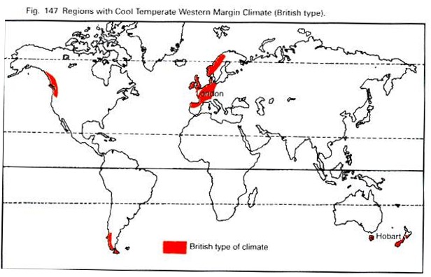
Cool temperate western margin [British type]:
This climate sees mild summers and winters and so a low annual temperature range. This season is suitable for maximum mental alertness and productivity. Therefore these regions are known as the Maximum Productivity region of the World.
The mildness of the temperature is also due to the influence of the North Atlantic drift.
There are four seasons: Small winters where snowfall is expected, spring which is dry and refreshing, summer which is long and sunny and then autumn or fall when leaves of trees fall down. Autumn season is a characteristic of the temperate regions as it is absent in tropics.
Warm summer, cool winters. Best for human habitation and low annual range of temperature.
Temperate cyclones give rainfall in winter. Rainfall from Westerlies and so west coast receives the most rainfall.
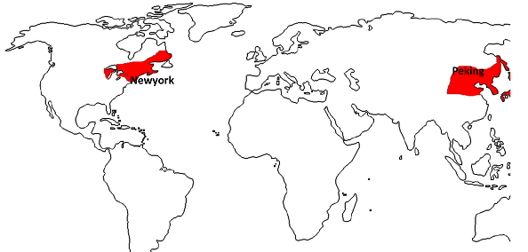
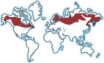
Cool temperate eastern margin [Laurentian type] and Continental area [Siberian Type]:
Coniferous forests are found in Siberia, Taiga is the greatest single band of coniferous forests. The Siberian type of climate is completely absent in the Southern hemisphere due to the narrowness of continents in the high latitudes as well as the moderating influence of the oceans. Coniferous forest has limited tree species like Pine, Fir, Spruce and Larch.
They are commercially exploited for soft wood. The World’s largest softwood producer is USSR, USA is leader in wood pulp and Canada is leader in Newsprint. A luxurious coniferous forest has made this possible.
Vegetation of non-conifers is low due to harsh conditions like small summers. Conifers have adapted themselves to this climate by showing remarkable features like:
Not in southern hemisphere as hardly any land below 40 degree. In North America, rainfall throughout the year. Temperate regions have profitable fishing and coniferous forests. Found only in northern hemisphere.
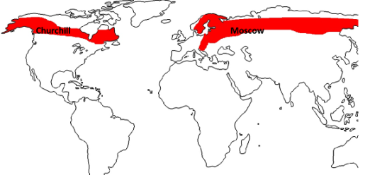
Taiga
Found between tundra region and Laurentian climate. Very cold winter and warm summer. High annual temperature range. Rainfall throughout the year and temperate cyclones. Found only in northern hemisphere.
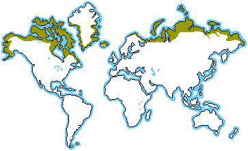
Tundra:
Tundra vegetation is seen here in the low lands where a few frost free months are there. Polar climate is seen mostly in the Northern part of North America continent and Northern part of Russia. Ice caps are seen in the Greenland area.
Freezing in winter. Thawing in summer. Aborigines are seen. Ephemeral [short lived] flowering plants. Found only in northern hemisphere.
Solved Question Papers
Q.Consider the following statements
1. The winds which blow between 30 degrees N and 60 degrees S latitudes throughout the year are known as westerlies.
2. The moist air masses that cause winter rams in North-Western region of India are part of westerlies.
Which of the statements given above is/are correct? (UPSC CSAT 2015)
Ans . B
Q.“Each day is more or less the same, the morning is clear and bright with a sea breeze; as the sun climbs high in the sky, heat mounts up, dark clouds form, than rain comes with thunder and lightning. But rain is soon over.” Which of the following regions is described in the above passage? (UPSC CSAT 2015)
Ans . B
Chapter Review
Score more than 80% marks and move ahead else stay back and read again!