-
Chapter 4: NATURAL CATASTROPHIC EVENTS
Introduction
The major types of natural calamities are
1. Volcanoes
2. Earthquakes
3. Tsunami
Volcanoes:
Volcanism
and
causes of volcanism aren’t random. The areas of high volcanic
activity are of ocean - ocean convergence and ocean continent
convergence.
One of the regions is the Pacific ring of fire located in the pacific ocean and consists of border areas of China, Philippines, Japan, rocky mountains, Mexico , Andes mountains, Indonesia, new Zealand, Tanzania.
The second reason for volcanoes is the ocean - ocean divergence which creates peaceful basaltic eruptions as mid ocean ridges are formed.
The third reason for volcanic eruptions is breaking up of plates into blocks. The andesitic eruptions are seen in this type.
Intrusive land - forms:
1. Sills - Horizontal
2. Dykes - vertical
3. Laccoliths – magma which couldn’t come out
4. Balolith – intrusive granite rock
5. Phacolith – shaped like waves
6. Lopolith – saucer shaped.
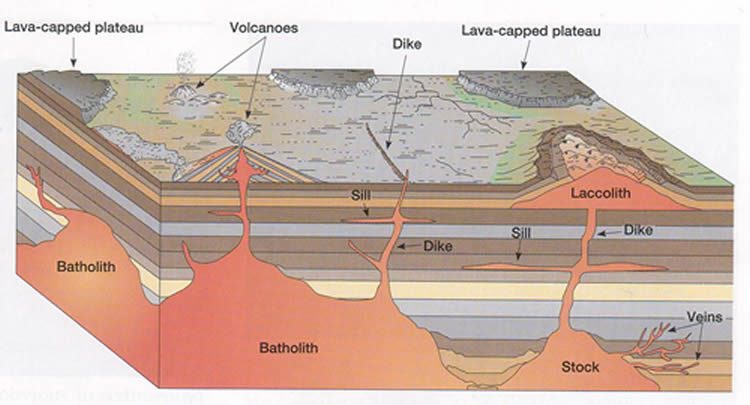
Fig 1: intrusive
landforms
Extrusive Landforms:
Lava plateau: The cracks in the continental crust leads to basaltic flows which spread across land creating lava plateau. E.g. Deccan plateau.
Shield / Dome volcano: The magma reservoir creates volcanic islands. These create peaceful basaltic flow with gentle flow. E.g.: Hawaii.
Cinder cones: The ocean continent plates collide and then viscous lava explodes violently.
Composite cones: Volcanic eruptions led to new layers of ash or lava.

Fig 2: Volcano types
Geysers:
Fountains of hot water. Ground water heated by shallow source of magma. They have chambers in interior and water comes out like fountains due to pressure. Silica is dissolved in water.
Hot springs:
Springs: The groundwater stored in rocks comes out of outlets called springs where the water table reaches the surface. The water may seep out gradually out of rocks or gush out as a fountain. Wells are man made for obtaining ground water by digging a hole in the ground till the water table is reached.
Water reaches interior and there it is heated. Water is heated by magma or hot rocks. It is common and is present in many places of the world. Cyano bacteria are present in this water.
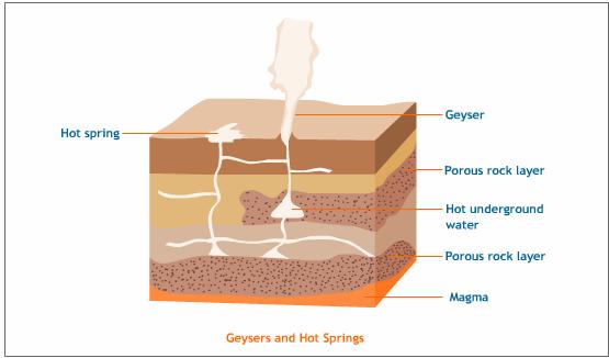
Fig 3: Hot springs vs geysers
DROUGHTS
Drought is a continuous and lengthy period during which no significant rainfall is recorded. In India, the Meteorological Department of India defined drought as a period of at least 22 consecutive days on none of which is there more than 0.25 mm (0.01 inch) of rainfall. However this definition doesn't apply to the whole country.
In general, the areas recording less than 60 cm of rainfall annually and in which the variability of rainfall is more than 20 per cent are the drought prone areas in India.
Areas where the variability of rainfall varies between 20 to 60 per cent (like Rajasthan, west of Aravallis, and east of the Western Ghats) are the chronic drought prone areas.
Ministry of Agriculture and the Ministry of Environment, a drought prone area is defined as one in which the probability of a drought year is greater than 20 per cent. A chronic drought prone area is one in which the probability of a drought year is greater than 40 per cent. A drought year occurs when less than 75 per cent of the average annual rainfall is recorded.
The drought prone areas of India are:
The Arid and Semi-arid Areas of Rajasthan
The Rain-shadow Areas of Western Ghats
Chapter Review
Score more than 80% marks and move ahead else stay back and read again!