-
Chapter 3: LANDFORMS ON THE EARTH
Introduction
Landforms on the earth are:
1. Mountains
2. Plateaus
3.
Plains
Types of Landforms
I. Mountains
They are of two types: Block Mountains and Fold mountains.
Mountain Building Process:
1. Pull of descending limb of the convention current. The compressive force is exerted by the convention current.
2. Geosynclines are elongated narrow depressions on continental margins. Here the sediments of marine origin are deposited by oceans and rivers.
Types of Mountains
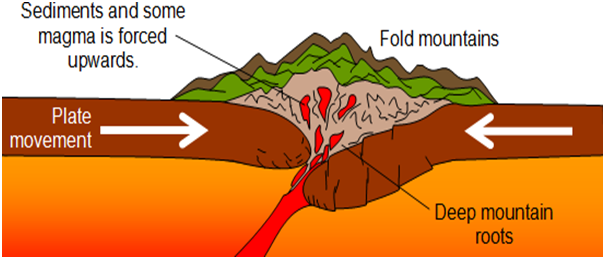
Fold mountains:
Fold Mountains are also called true mountains and are the youngest mountains of the earth. They are formed due to compressive force of the plates. They can be either of continental – continental convergence origin or continental - oceanic convergence origin. Therefore only compression is the force that creates Fold Mountains.They are the most widespread and most important. These are associated with volcanic activity and mineral wealth. They are called mountains of elevation. The compressive forces push the layers of the earth upwards and these are formed into mountains.
Characteristics of Fold Mountains:
1. Extensive mountain chain
2. Great heights
3. Formed along unstable part of the earth
4. Sedimentary deposits of marine origin if formed from continent - continent convergence.

Fig
2: Block mountains
Volcanic mountains: These are formed when materials ejected from the earth’s crust erupts from the vent of the mountain. This material accumulates around the vent of the mountain. Therefore volcanic mountains are called mountains of accumulation.
Residual mountains: These are mountains formed from the effects of denudation agents like rivers, air, breeze etc.
Plateau:
This is raised land higher than surrounding areas. It is formed during mountain building process. It is raised land due to erosion of mountain from glaciers or deposition from winds or lava.
Tectonic plateau: These are formed by earth movements that cause uplifts and are normally of considerable size and altitude. Intermount plateaus are plateaus enclosed by fold mountains. These plateaus are the most extensive and highest in the world. E.g: Tibetan plateau
Volcanic plateau: Molten lava may issue from the Earth’s crust and spread over the Earth’s surface to form successive sheets of basaltic lava.
Dissected plateau: These are formed from the action of glaciation and rivers on plateaux
Plains:
These are flat areas with low heights. These are the most populated areas of the world. They are most fit for human habitation.
The depositional plains are formed due to rivers or sea. Erosion plains are formed due to erosions of plateau.
There may also be low hills that form a rolling topography.
Structural plains: These are formed by horizontally bedded rocks. These make up some of the extensive lowlands of the world.
Depositional plains: These are plains formed from depositional material brought by agents of weathering like rivers, glaciers etc. Running water is the single most potent agent of denudation.
Erosional plains: These are plains formed from the action of agents of erosion like rain, rivers, ice and wind.
Lava and Volcanic Activity
Lava:
The main types of lava are:
Basic lavas: These are hottest lavas and highly fluidic. They are rich in iron, magneisum but poor in silica. They flow fast and without explosions and so cover more areas. The resultant volcano is flat dome or shield.
Acid lava: These are highly viscous and flow less fast. They also explode loudly.
Volcano:
Shield volcanoes: highly fluid, gentle rising slopes and broad, flattened tops.
Cinder cones: less fluid lava with large craters and steep slopes.
Composite cones: highest and most common type.

In some volcanoes the top of the cone collapses into the vent or is blown off. This orifice gets widened forming a caldera. Sometimes a lake may form in this depression and is called a Caldera lake.

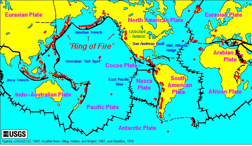
The greatest concentration of volcanoes is along the Cir-cum Pacific region which is also known as the “Pacific Ring of Fire” which has 2/3rds of the world’s volcanoes. It is also the region that sees the highest concentration of earthquakes as nearly 70% of the earthquakes are seen in this region.

Famous river plains in the world:
1. Yangtze river plain:
· Third longest river in the world.
· Iron and steel industries / Coal industries located on the coast.
· Used as an inland waterway.
2. Tigris and Euphrates river plain:
· Originates in turkey and flows through Syria and Iraq.
3. Amazon basin
· Second longest river in the world.
· Large mineral reserves and oil reserves.
4. Mississippi basin, USA
· Temperate grasslands and mineral reserves.
· Granaries of the world – Prairies.
5. Murray – Darling basin, Australia
· Temperate grasslands – Downs
· Animal husbandry and mineral reserves.
Lakes
Most of the lakes in the world are fresh water lakes and a few that have limited source of water and face high evaporation are salt water lakes. Lakes are however only temporary land-forms and shall be erased due to siltation and evaporation.
Factors responsible for lake formation:
- Lakes formed due to Earth movements:
- Tectonic lakes: These are formed due to movements in the Earth’s crust. E.g.: Lake Titicaca which is the highest lake and Caspian Sea which is the largest lake.
- Rift valley lakes: These lakes are formed due to sinking of land between two parallel faults. E.g.: Lank Tanganyika the World’s deepest lake and Dead sea , the World’s lowest lake.
- Lakes formed by glaciation:
- Cirque lakes: A glacier on its way down the valley leaves behind circular hollow in the heads of the valleys up in the mountains which become lakes.
- Kettle lakes: These are depression in the outwash plain left by the melting of masses of stagnant ice.
- Rock hollow lakes: Formed by valley glaciers that scoop out hollows in the surface. E.g.: Finland has 35000 such lakes and is called Land of Lakes.
- Lakes formed by Volcanic activity:
- Crater or Caldera lake: When the top of the cone is blown off during volcanic explosion a crater or caldera is formed in which a lake may be created.
- Lava blocked lake: A stream of lava may flow across a valley and block a river thus damming it and creating a lake.
- Lake due to subsidence of a volcanic lava surface: The crust of a hollow lava flow may collapse leaving a wide and shallow depression where a lake may form.
Apart from these there are also lakes formed by erosion or deposition or formed from activities of man, animals and ornamental lakes.
Tourist industry has become the National occupation in Switzerland due to the presence of lakes in the Alps.
Chapter Review
Score more than 80% marks and move ahead else stay back and read again!